 |
 |
 |
 |
 |
 |
 |
 |
 |
 |
 |
||||||||||||||||||
 |
 |
|||||||||||||||||||||||||||
 |
||||||||||||||||||||||||||||
 |
||||||||||||||||||||||||||||
 |
||||||||||||||||||||||||||||
|
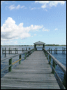
Rockland Public Landing, Rockland, Maine, USA
|
||||||||||||||||||||||||||||
|
We would like your comments - If you would like to add to this report or submit your own report on a marina, harbour or anchorage not covered in this guide so far please visit our contact page (see button above) for our email address. Digital photos are also very welcome. General - Rockland Public Landing lies in Rockland Harbor on the W coast of Penobscot Bay Position - 44° 06' N 69° 06.4' W Tides; Reference port - Mean time differences - HW: minutes ± ; LW: minutes ± Heights in metres -
Charts, Pilots & Cruising Guides - See the following link for Maine Charts Approach & Entrance; From Penobscot Bay to Rockland Harbor to end of the S channel Berths & Moorings - 15 slips all for visitors. 20 visitors moorings. Maximum length - 120' Formalities - Not known Contact ; Tel - Fax - Web VHF Ch - 9 Call sign - Water - On the pontoons Electric - On the pontoons Fuel - None. Weather forecast - Not known. Security - Not known. Internet Access - Not known. Other Facilities & Services - Toilets. Showers. Laundry. Pump out. Book exchange Chandlers/Ships Store - Not Known Shop Online for the Best Deals Marine Electronics - The Top Deals are on the Web! Scuba Diving Gear - Get Offers Here Fishing Tackle - Not Known Great Deals Online Shopping - Most provisions can be obtained. Eating Out - There are several restaurants close to Transport; Bus Service - Concord Trailways Car Rental - Great Deals Here!!! Limousine Service - Book your Limo Here Train Service - Water Taxi - Two Toots Ch.9, 594-2891 Ferry Service - ME State Ferries 596-2202. To North Haven, Vinalhaven and Matinicus Airport(s) - Knox County - 3 miles Bangor International - 55 miles Click here to Book Your Flights Local Area - Beach and picnic area. Farnswoth & Wyeth Center. Shore Village Lighthouse. Owls Head Transportation. The 4 mile Harbor Walk begins at the North End and continues to Snow Marine Park. We would like your comments - If you would like to add to this report or submit your own report on a marina, harbour or anchorage not covered in this guide so far please visit our home page for our contact details. Digital photos are also very welcome. Other reports on harbours, marinas and anchorages can be viewed in our marina guide
|
|
|||||||||||||||||||||||||||
 |
||||||||||||||||||||||||||||
 |
||||||||||||||||||||||||||||
 |
||||||||||||||||||||||||||||
 |
||||||||||||||||||||||||||||
 |
||||||||||||||||||||||||||||
 |
||||||||||||||||||||||||||||
 |
||||||||||||||||||||||||||||
 |
||||||||||||||||||||||||||||
